

Since my last post was somewhat inconclusive, I decided to do more research on the subject of Latin American residents in late-19th-century Spain, the majority of whom appear to have been returning Spanish emigrants and their families.
These maps raise as many questions as they answer. Returnees clearly concentrate in major cities - see Barcelona and Madrid -, but is their strong presence in major Andalusian ports only an effect of those port’s size?
The link between Spanish businessmen in Mexico and Spain’s northern belt is well documented, yet I hesitate to claim the same for Chile and Peru. I also doubt there’s any direct connection between the female-skewed gender ratios seen for low-migration countries and the more business-oriented profile that Spanish migrants to those countries apparently had.
First, let’s see if Latin American residents in the main Andalusian provinces were actually living in the major cities or dispersed throughout the provinces. To answer this, I examine the 1887 census data, which records foreign residents by municipality.
This is not ideal, since the 1887 census breaks down residents by nationality only for a few European countries1; all remaining foreigners are simply classified as “Other Country”. Still, it gives us a rough approximation of the settlement pattern of Latin American residents, assuming their pattern did not differ much from the overall Other Countries pattern.
The following map shows the number of Other Country (not necessarily Latin American) residents in each Andalusian municipality.
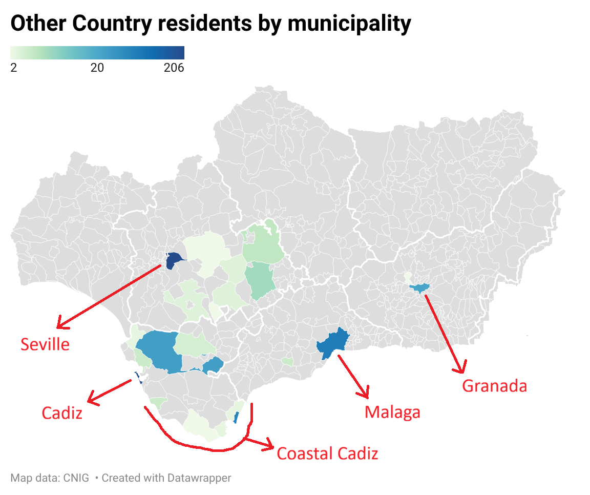
At first sight, it may not seem that Latin American residents were heavily concentrated in the three major cities of Cádiz, Málaga and Seville (most Spanish provinces are named after their capital city). This is partly due to limitations of the map’s color scale, and partly due to my use of the Other Countries numbers as a proxy for Latin Americans.
Out of Cádiz’s 46 municipalities, 11 had at least two foreigners. More importantly, more than 60% of those foreigners were Moroccans, which casts doubt on the validity of using the Other Countries category as a proxy. But there’s a catch. In the late 19th century, the municipality of Ceuta (YES, that same Ceuta you saw in the news) was part of Cádiz province and it recorded the highest number of Other Country residents in the province (332). Assuming all of them to be Moroccans, Latin Americans are still only around 40% of the province’s Other Country residents, excluding Ceuta.
Assuming that most foreigners in Cádiz’s coastal municipalities were likely also Moroccan residents (coastal Cadiz is right across the Strait of Gibraltar from Morocco), this still leaves open the possibility that many Latin American residents lived dispersed in that blueish-green area between Seville and Cadiz that you can see on the map.
But before discarding the idea that Spanish returnees concentrated in major cities, I should probably clarify what I mean by a “major city”. Of the three cities I’ve mentioned so far, Seville and Málaga had more than 100,000 inhabitants each, yet even Cádiz - with only 62,000 people - was several times larger than the average Spanish provincial capital. The next largest city on the map2, Jerez de la Frontera, was just as big as Cádiz (61,700).
How big were some of the other green-colored municipalities on the map? The following chart compares their populations to the populations of the 22 smallest Spanish provincial capitals3.
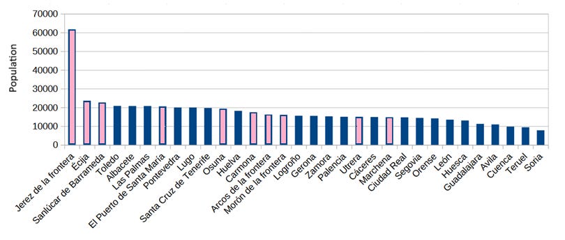
They were generally quite big. If we take this to mean that foreign residents living in cities of more than 16,000 people should not be considered as “dispersed”, then the updated map of Andalusia looks like this:
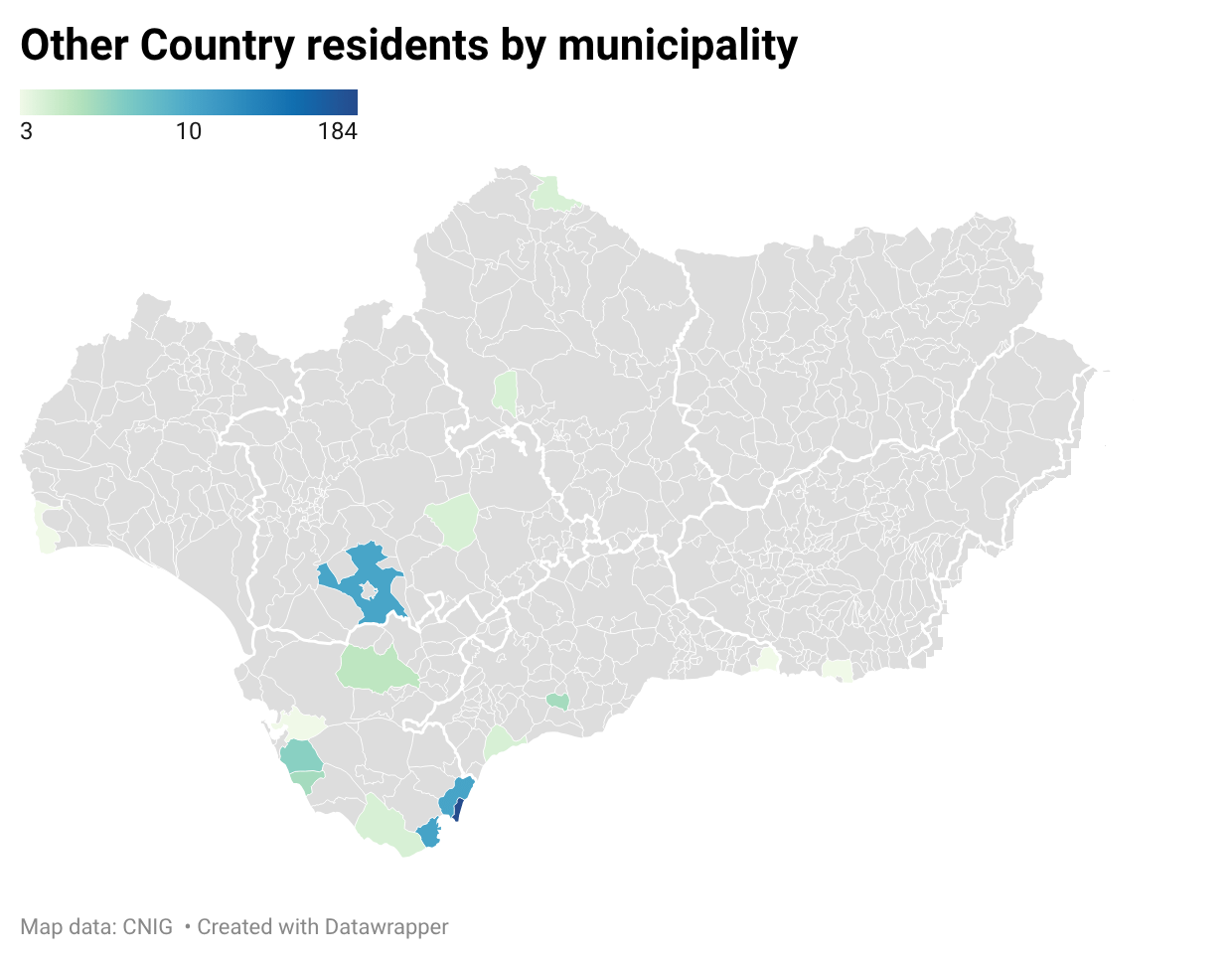
Beware that his map uses data from both the 1887 and 1877 censuses4, additionally suppressing municipalities with only two Other Country foreigners, in order to reduce noise and show more meaningful information. And it shows a highly concentrated population (except for coastal Cádiz, which I’ve already discussed), with little dispersion across Andalusia.
The northern belt
That was a rather roundabout way of arguing that returnees and their families overwhelmingly settled in Spain’s major cities. Maybe I could have simply pointed out that Seville accounts for 84% of Other Country foreigners in its province5, and the city of Málaga for 92% in its own province. Cádiz accounts for 56%, but rises to 67.7% when its entire metropolitan area is included6.
Outside of Andalusia, Barcelona and Madrid, the two biggest cities in the country, account for 89%7 and 98% of the residents in their respective provinces. Again a very high share. But not every Spanish province showed such a strong concentration of Other Country residents in its capital city, giving me another opportunity to present a map of Spain’s provinces. This map will clarify whether the percentage of Other Country residents in each provincial capital follows any evident pattern.
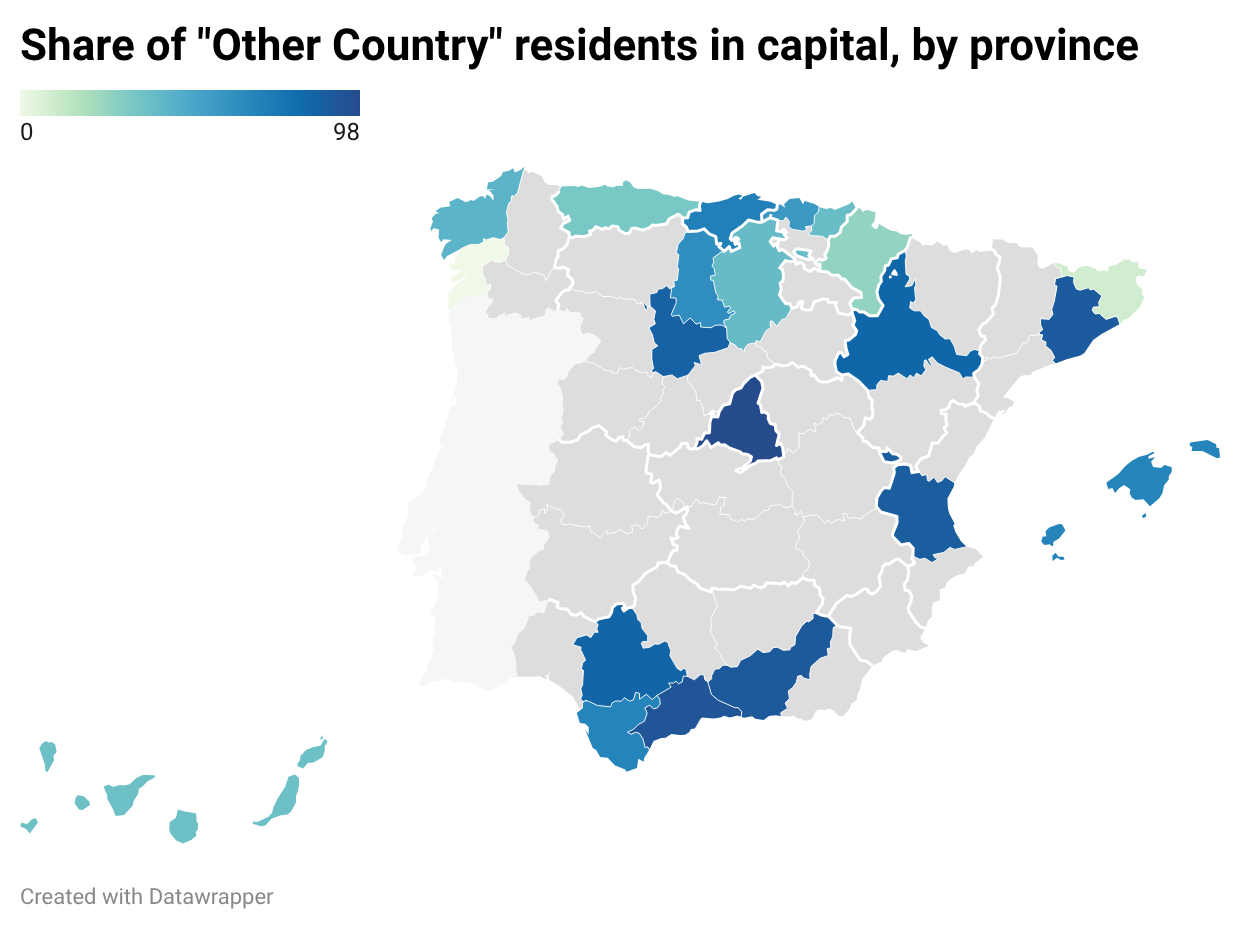
And it does. With the exception of the Canary Islands8, southern and central Spanish provinces had high shares of residents-in-capital, usually above 70%, while the percentages in northern Spain varied between 0% and 70%, with an average of around 40%.
So Other Country residents in Spain tended to concentrate in big cities in the south, while dispersing more widely in the north (with the exception of Barcelona). These figures refer to Other Country residents though, rather than Latin American residents. So let’s exclude provinces where the overwhelming majority of Other Country residents are non-Latin American and see how the updated map looks.
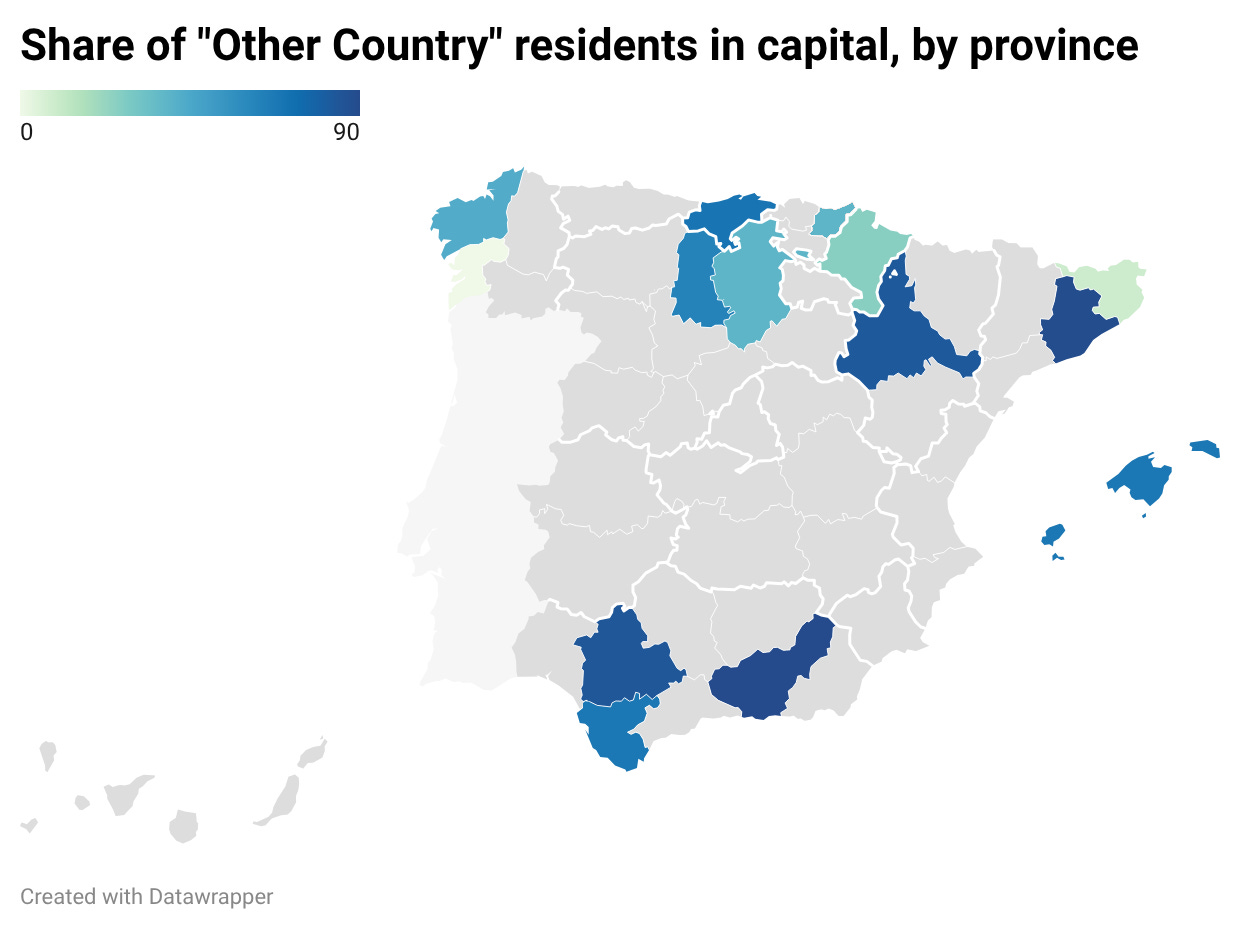
Although this updated map is uglier, it is more valid as evidence of the greater dispersal of Latin American residents in northern Spanish provinces (remember we are using Other Country residents only as a proxy for Latin American residents).
I haven’t yet proven that this dispersed settlement pattern exists, but for now let’s assume a high probability that it does and drill down to the municipal level. If Latin American residents were indeed living more dispersed in northern provinces such as Navarre, Burgos and Cantabria, let’s examine that dispersion on a map of northern municipalities9:
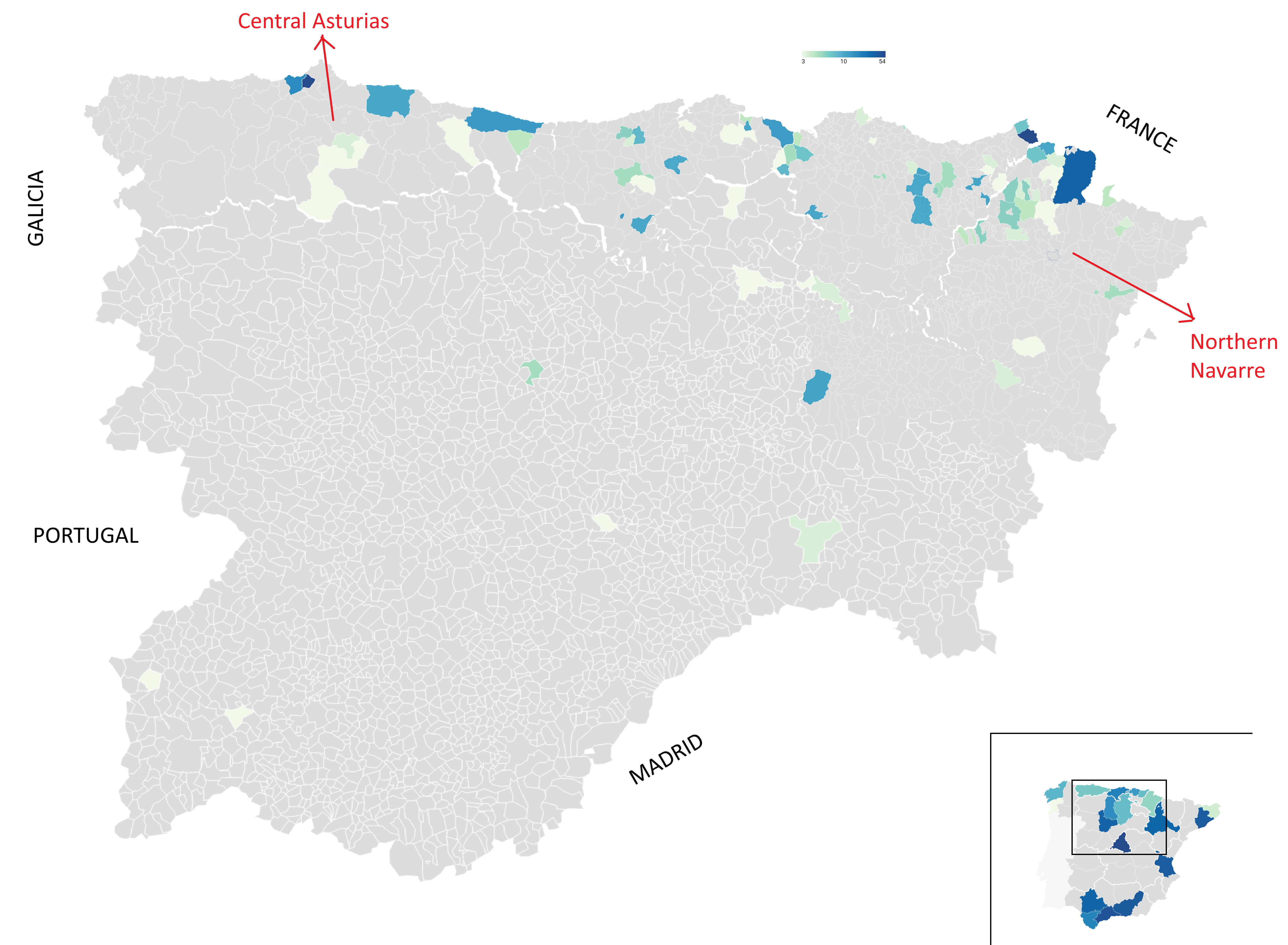
(I’m sorry about the white cracks between regions. Datawrapper does not provide an easy to use map of all Spanish municipalities, so this is a handmade composite of several regional maps)
Almost all of these Other Country foreigners lived in what I’ve called the northern belt, going from central Asturias to northwestern Navarre. This is a more precise picture than the map of Spanish provinces we examined in the previous post, which implied that the belt ran from Asturias to Navarre. In reality, western Asturias and southern Navarre had almost no Latin American residents, making the northern belt even smaller than it first appeared.
You might wonder whether the Other Country numbers at the eastern end of the northern belt, where it borders France, are skewed by French residents. But that is not the case. French residents were recorded separately, so any Other Country residents distorting the figures of bordering municipalities would likely be Belgians, Dutch, Swiss or Norwegians.
These Belgians, Dutch and other Europeans presented a very different gender ratio than Latin American residents10. In Gipuzkoa (the Basque province right next to France), Belgian residents were 31.5% female in 1887, and the Dutch were only 17.5% female. In Asturias, at the other end of the northern belt, the Swiss were 25% female and the Dutch 21%.
These male-skewed gender ratios are distinct from those of the Latin American residents with a strong presence in the northern belt (Argentine, Mexican, Peruvian, Uruguayan), as we saw in the previous post. Most Latin American nationalities showed ratios around 50%, and Mexicans in particular came close to 60% female.
The only main city11 in the northern belt whose Other Country residents are not male-skewed is Oviedo, the capital of Asturias. This suggests that male-skewed European residents (Belgians, Dutch, etc) predominantly lived in the main cities, and therefore the Latin American share of the population living outside the main cities was significantly higher than their share of the province as a whole.
So those dispersed Other Country residents we see on the map, outside the main cities of the northern belt, are very likely Latin Americans living in small towns and villages.
In northwestern Navarre, many small municipalities with two or more Latin American residents12 had fewer than a thousand inhabitants, usually producing ratios of 2-15 Latin Americans per 1,000 population, higher than any Andalusian town except for the largest cities (Cádiz, Málaga and Seville). And the presence of Latin American residents (probably returnees) in these small towns aligns with what we know about Spanish immigrants in 19th-century Mexico13:
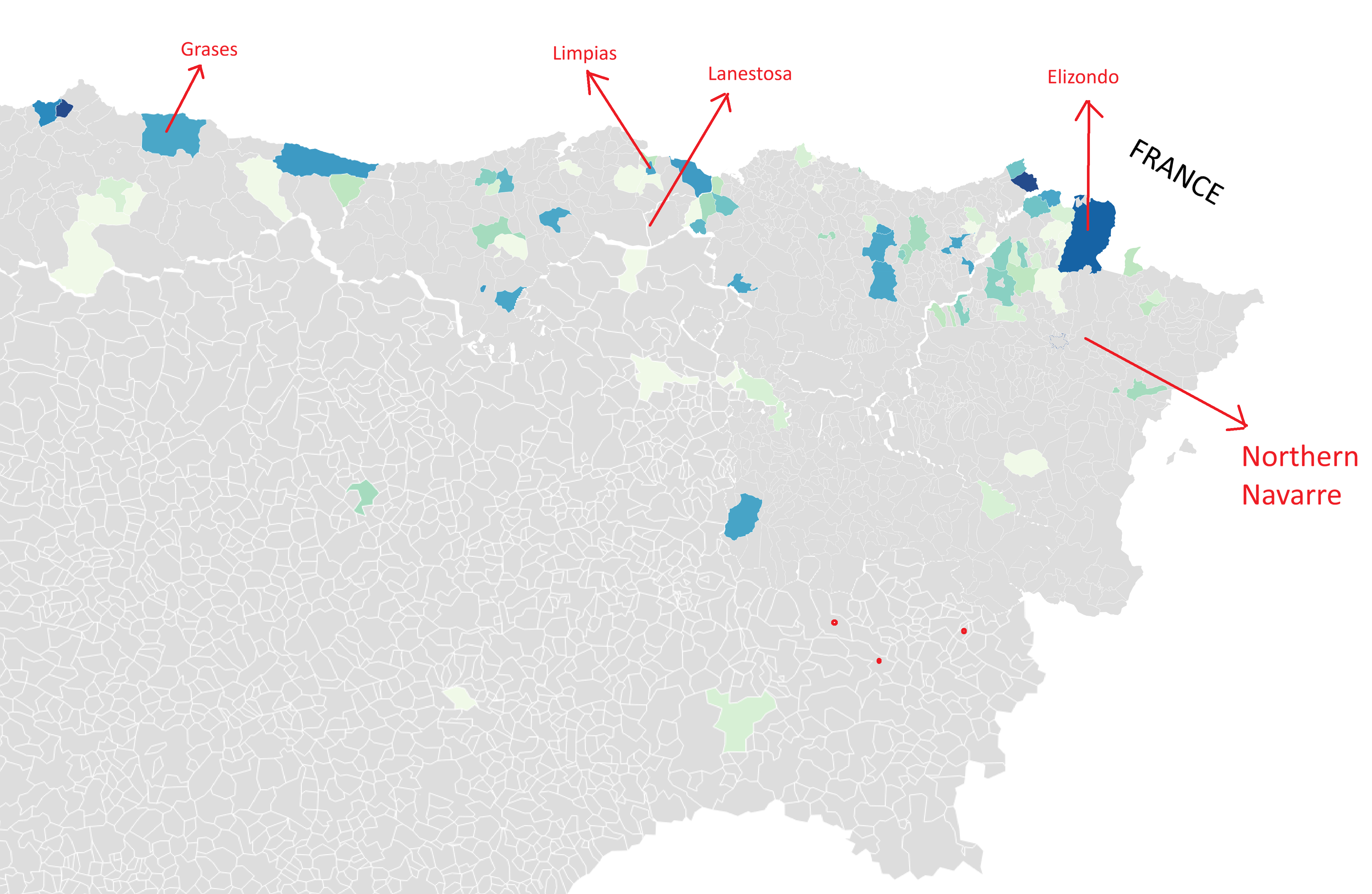
In most cases, the [Spanish] peninsular immigrants who arrived in western Mexico during the 19th century came from the northern provinces of Spain: Vizcaya, Catalonia, Cantabria or Asturias, from small towns14 near the sea, Lanestosa, Elizondo, Limpias or Graces [sic]
All of the small towns named by Sergio Valerio Ulloa in the quote above are located in the northern belt, though not always close to the sea. Three of them are in municipalities that recorded Other Country residents in the 1877 and 1887 data15.
A similar picture emerges when looking at the towns of origin of Spaniards living in the Mexican city of Puebla around 1930, as listed by Leticia Gamboa Ojeda16.
Of the 25 small and medium-sized towns explicitly named by Gamboa Ojeda, 10 are located in central or eastern Asturias and only one is in western Asturias, matching what we’ve already seen in the census data. Of the rest, more than half are located in Cantabria or in the neighboring provinces immediately to the south of Asturias and Cantabria (León and Palencia), near the border.
(Gamboa Ojeda also mentions a town that she couldn’t locate: “Ten [immigrants] are recorded as coming from Spain, without further detail, and one from San Juan Beleño, a town whose geographical location we have not been able to establish“. It is a testament to how much historical research should have been transformed in the last thirty years (but hasn’t?) by digitization, the internet and LLMs that it took me less than ten seconds to establish that San Juan Beleño is a locality in the Asturian municipality of Ponga.)
Also, apart from two or three towns in Galicia, only two towns on the list appear to be outside the northern belt, one in León province (Val de San Lorenzo) and one in Soria province (Trévago). Soria also happens to be the province of origin of the Spanish family that founded La Soriana, one of the largest retailers in Mexico. Which is interesting because every other highly successful Mexican businessman of Spanish origin appears to be either born in the northern belt or was the son of an immigrant from there17. Is that just a coincidence?
Well, if we move from Mexico to Peru (another country I named in my last post), we find a similar pattern in the regional origins of successful Spanish immigrants, though with very few Asturians and more Basques. In contrast to Spanish migrants to Mexico, migrants to Peru (or their children) also achieved success beyond business. Cotton magnate Luis Albizuri Elejalde18 became mayor of Lima, mining businessman Luis Gallo Porras19 also served as mayor of Lima and as a state minister, and renowned surgeon Francisco Graña Reyes20 was a member of the Peruvian parliament21.
Calixto Romero, who left Spain as a sixteen-year-old to try his luck in the Americas, may have been the most successful of them all. As the founder of the Romero Group, currently Peru’s second-largest economic conglomerate, the Spanish migrant went from humble beginnings to become one of the country’s leading industrialists. Moreover, he was born in Soria; in the small town of Langosto22.
So, Soria sort of surprised me.
The province is not far from the northern belt (you can see the three places where our Sorian immigrants were born, marked as red dots on the map above), and the sampling methodology is not ideal23, yet finding three Sorians among the immigrants in these Peruvian and Mexican lists was not something I was expecting.
Conclusion (sort of)
The northern belt’s geographical boundaries are not exactly what I had previously thought. Western Asturias appears to fall outside the northern belt, and there’s a chance Soria might be within it.
This may seem like nitpicking over details, but I believe that establishing the precise origins of this small stream of Spanish migrants, yet outsized in its economic and political influence in their destination countries, will help explain both the reasons for their success and the influence they had on the American countries that received them.
(Credit for this post’s thumbnail goes to Baúl del Arte. The picture shows the Church of St. Mary Magdalene, in Langosto, Soria.)
France, Italy, Germany, Portugal and the UK.
Well, Granada, with 73,000 residents, is also on the map.
That is 22 out of the 50 provincial capitals.
They are not the exact same data. The 1877 census records the country of birth of residents, not their nationality.
Including those living in municipalities with populations over 16,000.
Another 25% resided in La Línea de la Concepción, right across the border from Gibraltar.
92.3% if we include its entire metropolitan area.
At the time, the Canary Islands constituted a single province rather than the modern-day two provinces. Therefore, I calculated the share of residents living in its only capital city, Santa Cruz de Tenerife. If I include both modern capital cities, the share only rises from 36.3% to 44.7%.
For the Basque provincial capitals of Bilbao (Bizkaia) and San Sebastián (Gipuzkoa), I excluded all municipalities that today form part of their metropolitan areas.
Provincial gender ratios are calculated from the 1887 census. The 1877 census did not record gender ratios of Other Country residents by nationality.
I counted eight main cities in the northern belt.
In Navarre, Other Country residents were 80% Latin American in 1887 and 88% in 1877, so a small Navarrese town with two Other Country residents was highly likely to be a town with two Latin American residents.
See “La otra orilla del mundo. Cántabros, vascos y asturianos en el occidente de México durante el siglo XIX“, by Sergio Valerio Ulloa.
This is “pueblos” in the original, which carries a connotation closer to village than to town.
Grases is situated in Villaviciosa municipality. Elizondo is the capital of Baztán Valley municipality.
See her essay in “Una inmigración privilegiada: Comerciantes, empresarios y profesionales españoles en México en los siglos XIX y XX”, 1994, edited by Clara E. Lida.
This includes the founders of the major retail chains La Comer, El Nuevo Mundo, Aurrerá and Gigante. Also a few major industrialists.
Although Albizuri was born in Madrid, both of his father’s surnames as well as both of his mother’s surnames were Basque, so I assume a Basque origin.
Gallo’s family was apparently related to another very prominent Peruvian Gallo family, that of Francisco José Gallo Díez. Both originating from the town of Escalada, Burgos, near the border with Cantabria.
Though Graña’s father was born in Paderne, a small town in Galicia, near La Coruña.
All of these immigrants are mentioned by Ascensión Martínez Riaza in “A pesar del gobierno. Españoles en el Perú, 1879-1939“ (2006).
By the time of Romero’s birth, Langosto had been merged into the municipality of Hinojosa de la Sierra. Hinojosa de la Sierra was subsequently merged into the municipality of El Royo, in whose school Calixto Romero apparently studied for a few years.
Those of the Northern rural spread were called "indianos" (also "amerikanuak" in Basque, i.e. "Americans") and were people who went to America as entrepreneurs and returned filthy rich. They characteristically decorated the front gardens of their mansions with two palm trees. I'm a bit perplex at the high density in Irun, which is rather an industrial town, but otherwise they fit in the desrciption.