
Some musings on agriculture and demography: Immigration in a Spanish province
How geography and weather influence migration patterns.

I’ve now left the Canary Islands, but before going back to my now usual place of residence in Spain1, I decided to take a detour and visit the province of Huelva2 in the southwestern corner of Spain, right on the border with Portugal.
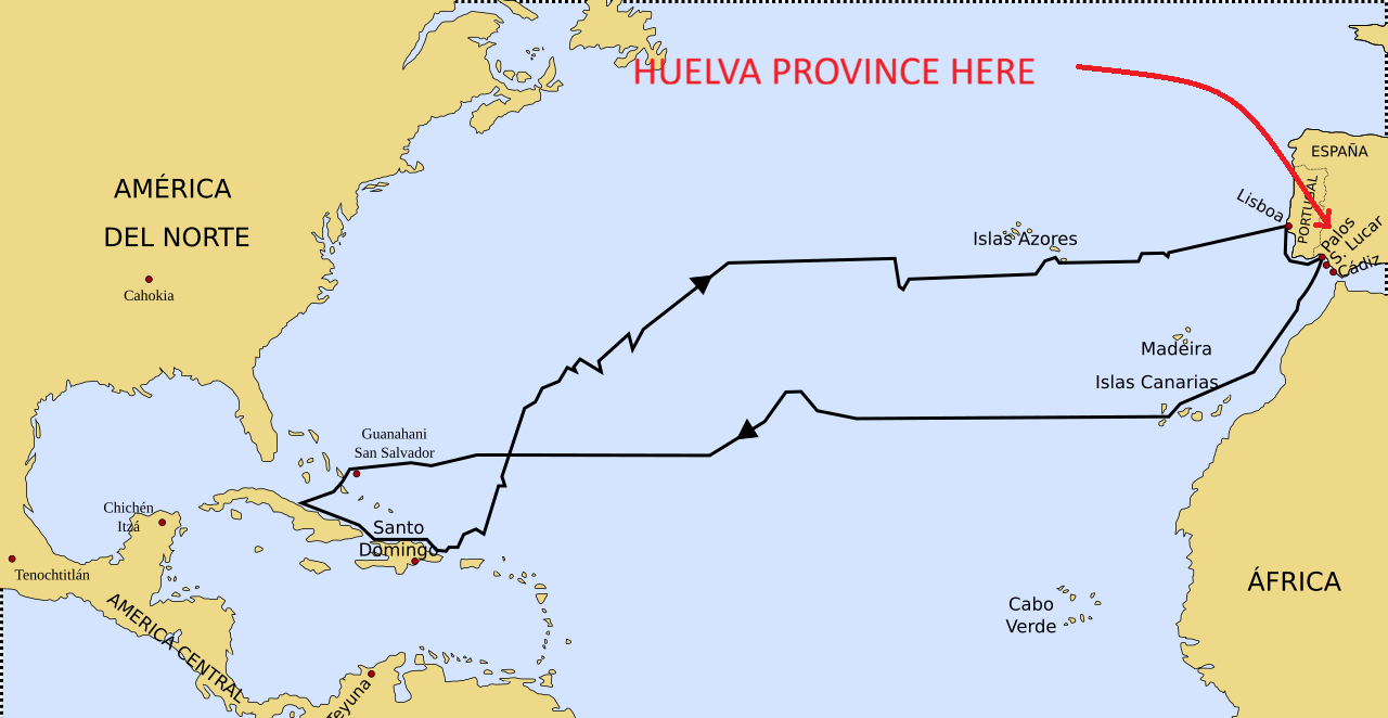
Have you noticed that all books and articles about the voyages of Christopher Columbus to the New World seem to include a map like this one?
Well, that dot labeled “Palos“ corresponds to the town of Palos de la Frontera, in Huelva province. And if we zoom in on the coastal area where Palos is located, it looks like this (modern map, so ignore the roads and highways):
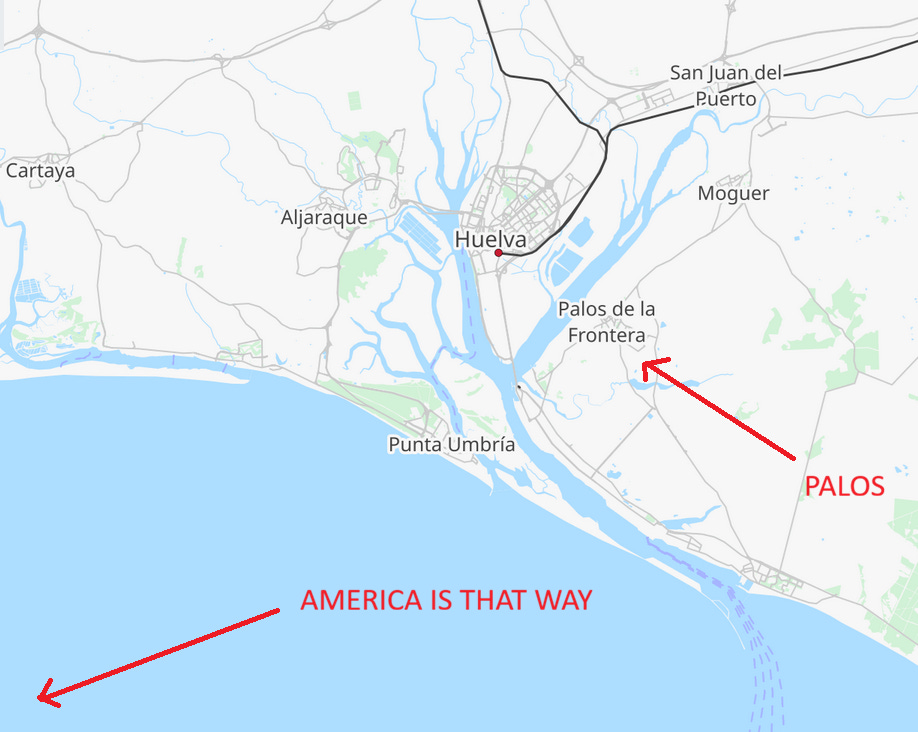
Revealing that this Palos de la Frontera port from which Columbus departed is not actually located on the coast but on a riverine estuary, offering good access to the sea while at the same time serving as a well-protected harbor. Estuaries make excellent locations for maritime ports, and some of the world’s most important ports (Shanghai in the Yangtze estuary, Sidney Harbor, Antwerp in the Scheldt, San Francisco Bay) are located in them. As a history nerd, of course I wanted to visit Palos de la Frontera simply because of its role in the early voyages to the Americas, but its peculiar geographic location made the trip even more appealing.
If we zoom in even further on a satellite image of the Palos area (credit Google Maps), you can see the location of the old 15th-century port, to the left of the label “La Fontanilla“. You can also see the many, many silvery, unnatural-looking structures surrounding the town of Palos (locals don’t call it “de la Frontera”).
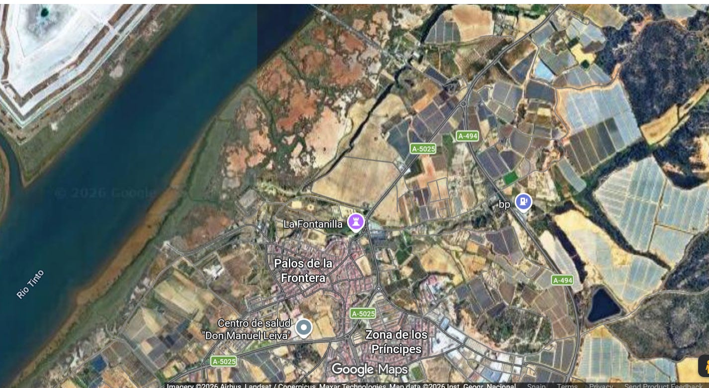
Those structures are not fake plastic trees3; they are very real plastic structures to support the cultivation of real trees (and shrubs). I was struck by how ubiquitous these greenhouses are throughout the province when I traveled from the city of Huelva (capital of the province) to the town of Moguer, passing through Palos along the way. They are everywhere.
Moguer is also closely tied to Columbus’ voyages - it was the port where the ship La Niña was built - so I was very keen to visit both places. After arriving in Moguer, the second thing I noticed (or maybe third, after “there aren’t many Columbus-related sights here; maybe I should have gotten off the bus at the La Rábida monastery like the other tourists…“) was how many foreign-looking immigrants there were in this small Spanish town. They are everywhere.
Granted, I live in the Spanish province with the second-lowest percentage of foreign-born population in the entire country, and a large share of those living here are kind-of, sort-of Spanish-looking Latin Americans like me, who don’t stand out (much). Walking around my hometown one might get the impression that recent reports about Spain’s very large immigrant population are grossly exaggerated4. In Huelva province, on the other hand, walking around Huelva city (10.2% foreign-born) didn’t feel particularly different from any other mid-sized Spanish city, yet arriving at Moguer, where 26.6% of its 22,000 population are foreign-born5, felt very different.
This begs the question: why is there such a high share of foreign-born population in the towns of Moguer and Palos (21.6%)?
Or, more generally, why do people migrate?
I’ve written before about how geography and weather can influence migration patterns, particularly in the case of Canary Islanders:
The fact that the island’s climate allowed for the cultivation of tropical crops was a distinct advantage not shared by mainland Spaniards, making emigration to the American tropics, where similar crops could be grown, even more appealing to [Canary Islanders]
These factors, together with the availability of economically exploitable resources in the receiving regions, explain a large part of the settlement patterns of the Americas. They explain why African populations were forcibly settled in the tropical lowlands, where a plantation economy used slave labor to produce tropical crops for European markets. They also explain why Canary Islanders settled in both tropical regions and sparsely populated border regions of Spanish America. More generally, they help explain why sparsely populated parts of the continent received more European immigration than areas which already had large indigenous populations before the Spanish arrival.
In economic terms, most free migrants moved to regions of the continent where their skills were more valued and wages were higher; or where other production factors - land in particular - were more abundant and cheaper, allowing for greater returns to their labor. And even in the case of unfree labor, African slaves were transported to areas where their labor was more valuable, though the slaves themselves clearly derived no benefit from this.
Today, in a world where almost every piece of land with good agricultural potential is already under intense cultivation, and where many middle-income and poor countries struggle with high levels of unemployment, migrants no longer move in search of land. They move in search of jobs and higher wages.
Back to Moguer and Palos
So, why is there such a high share of foreign-born population in the towns of Moguer and Palos?
Before answering that question, let’s go back to my home province of Córdoba, which has several mostly agricultural towns of a similar size to Palos and Moguer (10k to 25k population).
There’s even a specific Spanish term for these towns: Agrociudad (Agricity). It denotes a small city whose economy is based almost entirely on agriculture and services, with no industry. The term is not only useful for characterizing the economy of such cities, but more broadly as a way to portray the economy of Southern Spain - where almost all of these cities are located - as a region where very little industry exists outside of mid-sized and large cities.
All of these small cities in Córdoba province have relatively low immigrant populations (less than 5%6), and an African-origin immigrant population of less than 2%. The overwhelming majority of small cities in Huelva and Córdoba are Agrociudades, heavily dependent on agriculture, yet for some reason far more migrants come to work and live in Huelva than in Córdoba.
Both provinces suffer from high unemployment, but the rate is slightly higher in Córdoba (17.0%) than in Huelva (15.6%)7. It doesn’t seem like migrants choose Huelva simply because jobs are easier to find there, so why do they flock to agricultural cities in Huelva but not in Córdoba?
The answer is unskilled labor demand. This is what skilled agricultural labor looks like:
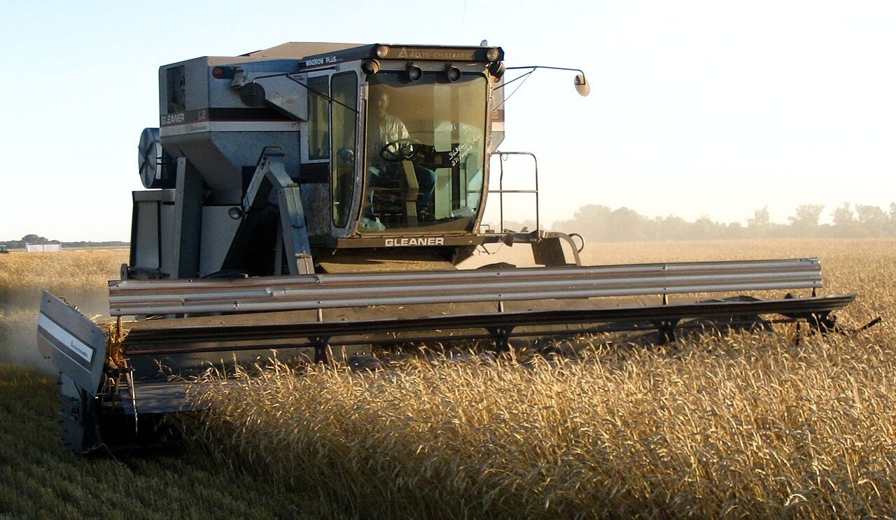
And this is what unskilled agricultural labor looks like:
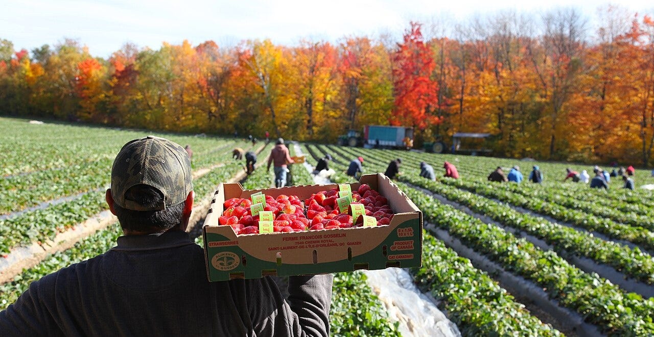
Córdoba province, being far from the coast, does not enjoy the mild weather that is ideal for growing garden vegetables and many fruits, but instead it produces a lot of wheat, over three times as much as Huelva8. Wheat farming is highly mechanized though, requiring little labor compared to other crops. If we want to find an agricultural product grown in Córdoba that requires a large workforce, we should look at other crops. The following map, showing the main crops in every region and province of Spain, should give us a good idea of what other major crops are grown in Córdoba.
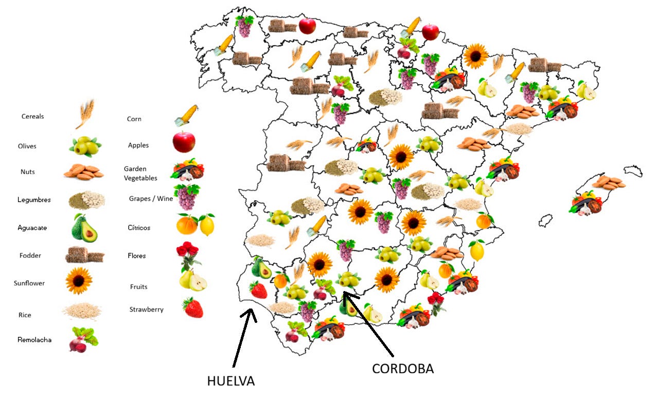
Although the map is a bit crowded, you can probably see that olives (mostly for oil), sunflower, and grapes (for wine) are Córdoba’s main crops besides wheat9. And a quick internet search will confirm that sunflower farming is just as mechanized as wheat farming.
That leaves us with olives and grapes. Somebody has to pick those fruits by hand, and countless hectares (acres) of olive trees and vineyards require countless unskilled laborers, right? Well, not necessarily. In case you are not up to date with the latest in agricultural machinery, let me present to you the mechanical tree shaker:
(I hate embedding videos, but there’s no better way to understand how shakers work without seeing one in action (or maybe visiting a friend who owns an almond farm). Also, this should be a caption but Substack doesn’t allow video captions…)
These modern agricultural machines have made it possible to harvest olives, and even grapes, employing little labor compared to traditional hand harvesting. And although in the case grapes the varieties grown in Córdoba10 are overwhelmingly harvested by hand, the wine industry does not generate a substantial demand for labor due to the limited vineyard area - less than 6,000 hectares11 - and the seasonal nature of the work.
In the words of the manager of one of the major vineyards in Córdoba12:
It’s a very difficult situation. Currently, viticulture is the most labor-intensive agricultural activity, and there’s a huge problem finding workers. One of the few positive aspects we see is the increased trend towards consuming young white wines.
In summary, Córdoba’s agriculture employs relatively little unskilled labor, and the seasonal nature of the work fails to draw migrants to the province.
In contrast, Huelva province has a much milder maritime climate. The kind of weather favored by German and British tourists, as well as by strawberries and cranberries. While it’s not much sunnier than Córdoba, the milder temperatures make it almost ideal for growing strawberries in greenhouses, and as a result Huelva accounts for over 90% of Spain’s strawberry production (did you notice the strawberry drawn over Huelva province on the map above?).
Strawberries are planted by hand and harvested by hand.
The same is true for cranberries and raspberries. And because these crops are harvested at different times of the year, they ensure a steady demand for unskilled labor, all year round.
Huelva’s ideal conditions for greenhouse farming create a strong demand for unskilled labor, so migrants naturally move to where the jobs are, which is where the berries are. Mind you, not all of Huelva province shares the same climate. The further inland you go, away from the sea’s moderating influence, the less economically viable greenhouse farming becomes. This geographical pattern of Huelva’s agriculture is mirrored by a geographical pattern of immigrant settlement, as you can see in the map below.
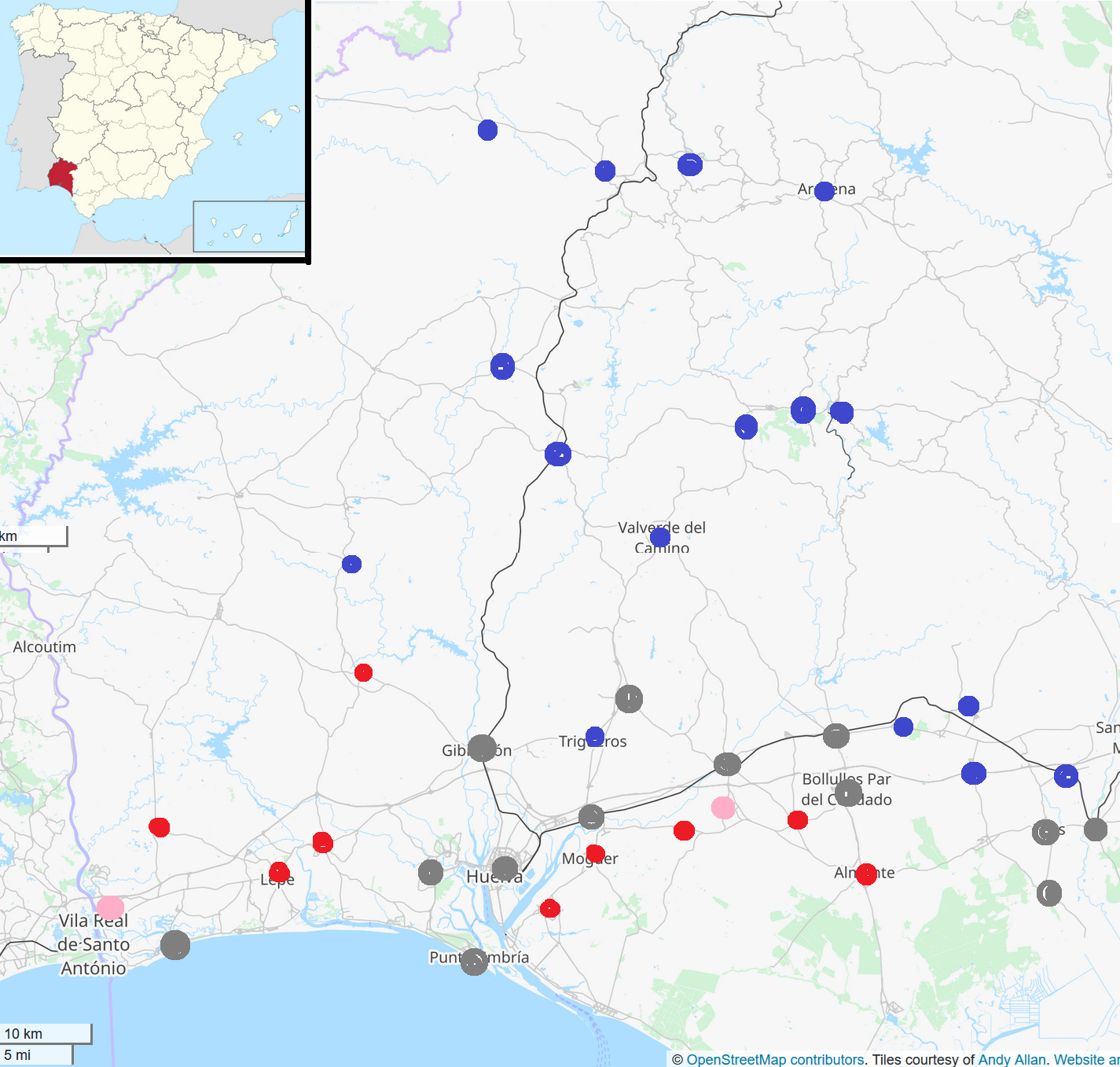
The central and northern areas of the province, as well as the eastern area near the Seville border, have attracted relatively few immigrants compared with coastal Huelva. And all because of the weather.
Even in this day and age, in our modern world, geography and weather still play a major role in determining who migrates and where.
No, I still don’t feel comfortable calling it home.
Pronounced: Ooehlvah.
I’m sorry. I can get Radiohead-levels of melancholic when I can come back from a trip.
Only 1% of the population consists of what one might call “highly visible” immigrants, born in Asian and African countries.
Source is Spain’s National Institute of Statistics (INE). See “Población por sexo y país de nacimiento (grandes grupos)“.
The foreign-born population share of the province as a whole is 5.7%.
Source: Spanish National Institute of Statistics (INE). Fourth quarter of 2025.
Córdoba’s neighbor to the east, Jaén province, has a similar mix of crops.
The main one is a thin-skinned variety called Pedro Ximénez. Thin-skinned are luddites.
That’s around 14,800 acres for my Myanmar readers out there. The area planted with wheat is ten times larger (around 60,000 hectares).
Interview with Antonio López, manager of bodegas El Monte. The bodega’s website confirms that harvesting is done by hand: “Todas las labores que tiene el viñedo, desde la poda hasta la vendimia son manuales“.
Greenhouse labor studies are very useful to see the current state of the countryside, we can see the demographic boom It caused (and still causes) in Almería, where a generally underdeveloped technique is balanced by the sheer number of greenhouses and still pays insufficient wages for the market demand of the fruits, meanwhile France or the Dutch countries pays enough due to their technological level being higher than there. Great read!